
The Complete Valuation Playbook for Geospatial Software Businesses
A practical breakdown of how geospatial software businesses are valued and what drives high multiples.

Geospatial software has moved from a specialist mapping function into core operating infrastructure. Buyers now look at location data, mapping workflows, asset intelligence, field operations, and spatial analytics as tools that can affect revenue, cost, risk, and compliance.
That matters if you are considering a sale in the next 1-12 months. The difference between a modest outcome and a premium outcome is rarely just "what industry you are in." It is usually about whether buyers see your company as a mission-critical software platform, a defensible data asset, a workflow tool, or a services-heavy mapping vendor.
This playbook will show what geospatial software businesses actually sell for, how public market multiples frame buyer thinking, what drives higher versus lower valuation, and what you can realistically improve before going to market.
1. What Makes Geospatial Software Unique
Geospatial software is not one simple category. Buyers separate the market into several types of businesses, and each one gets valued differently.
At one end, you have GIS platforms and mapping data providers. These businesses help customers create, manage, visualize, and use location-based information. They may sell map data, infrastructure records, terrain models, spatial databases, or cloud-based mapping tools.
Then you have geospatial engineering, surveying, and infrastructure software. These businesses often serve utilities, construction, transport, natural resources, defense, government, and urban planning. They can be more technical, project-linked, and services-influenced, but they may also be deeply embedded in customer workflows.
A third group is location-based operations software. This includes fleet management, telematics, routing, asset tracking, field operations, logistics, and industrial internet-of-things platforms. These businesses tend to be valued highly when they have recurring subscriptions, large installed bases, strong retention, and clear return on investment for customers.
A fourth group sits around sales, marketing, and location-driven customer engagement. These companies use location data to help retailers, venues, consumer brands, and multi-location businesses understand customer movement, improve local search visibility, or target marketing activity.
The unique valuation issue is that "geospatial" can mean very different things. A buyer may value one company as a sticky vertical software platform, another as a data provider, another as a services business, and another as a niche analytics tool.
That creates a wide range of possible multiples. In the source data, public geospatial and adjacent software companies range from below 1.0x revenue to well above 10.0x revenue, depending on scale, growth, profitability, margins, and strategic scarcity. Private transactions are more grounded, with an average revenue multiple of about 2.9x and a median around 1.6x across the provided precedent deals.
The risks buyers will always check are also sector-specific. They will ask whether your data is unique or replaceable, whether customers use the platform every day or only for occasional projects, whether revenue is recurring or project-based, whether the product depends on third-party data licenses, whether implementation requires heavy services, and whether your technology can scale without adding large amounts of people.
2. What Buyers Look For in a Geospatial Software Business
Buyers start with the basics: size, growth, profitability, margins, customer retention, and revenue quality. A USD 10m revenue business growing 25% with strong gross margins and mostly recurring revenue will usually be viewed very differently from a USD 10m revenue business with flat growth and one-off project income.
But in geospatial software, buyers go further. They want to know whether your product is mission-critical. In plain English: does the customer truly need your software to run their operation, make decisions, avoid risk, or serve their own customers?
A utility using your platform to manage underground asset records is different from a marketing team using a simple map overlay once per quarter. A logistics company using your routing and fleet data every day is different from a customer buying a one-time mapping dataset.
Buyers also care about whether your data and workflows are hard to replace. If you have proprietary spatial data, historical records, customer-specific workflows, regulatory use cases, or deep integrations into the customer’s operating systems, that creates switching costs. Switching costs simply mean it would be painful, risky, or expensive for a customer to leave you.
They will also study your revenue mix. The best software valuation stories usually have a high share of recurring subscriptions, strong renewals, low churn, and room to upsell more users, more modules, more data, or more usage.
How Private Equity Buyers Think
Private equity buyers look at your business through a simple lens: "If we buy this today, how can it be worth meaningfully more in 3-7 years?"
They think about the entry multiple - the multiple they pay you - and the exit multiple - the multiple they hope to sell the business for later. If they pay too much today without a clear plan to increase growth, margins, or strategic value, their return becomes harder.
They will ask who the next buyer could be. That might be a larger geospatial software company, an infrastructure technology platform, a fleet or logistics software company, a government technology buyer, a larger private equity fund, or in rare cases the public markets.
They will also look for practical levers. Can they increase prices? Can they sell more modules to existing customers? Can they reduce support costs? Can they add sales capacity? Can they acquire smaller competitors? Can they shift the business from services-heavy projects to repeatable software revenue?
The clearer those levers are, the easier it is for a private equity buyer to justify a stronger offer.
3. Deep Dive: Workflow-Critical Geospatial Data vs. Nice-to-Have Mapping
The most important valuation question in geospatial software is often this: are you a workflow system or a mapping feature?
That distinction matters because buyers pay more for software that sits inside important customer decisions. A visual map is useful. But a platform that helps customers manage assets, plan routes, reduce risk, comply with regulation, serve clients, or make operating decisions is much more valuable.
The deal data supports this pattern. The strongest premium drivers were seen where companies had strategic data-intelligence assets, decision-critical use cases, cross-sell value to an acquirer, specialized vertical expertise, and software-like margins. In other words, buyers paid more attention when geospatial data was tied to real operating outcomes.
A lower-value geospatial business often looks like a tool customers can use occasionally. It may provide mapping, visualization, or reports, but it does not own the customer workflow. The product might be useful, but not essential. That makes it easier for buyers to view it as a feature, not a platform.
A higher-value business is embedded in how the customer works. It may connect to CRM, enterprise resource planning systems, field service platforms, asset databases, logistics systems, sensor networks, or compliance workflows. It may help customers make daily decisions that affect cost, safety, revenue, or risk.
If your business looks more like the left column today, you do not need to rebuild the whole company in 6-12 months. But you can move the story in the right direction.
Start by proving usage. Show how often customers log in, what decisions they make, and what systems you connect to. Then package your best use cases into repeatable modules. If customers use you for asset planning, compliance reports, field routing, site selection, emergency response, or infrastructure decisions, make that clear in your commercial story and your data room.
Buyers do not just buy what your software does. They buy how important it is to your customers.
4. What Geospatial Software Businesses Sell For - and What Public Markets Show
Valuation data in geospatial software is wide because the category includes many different business models. A high-growth SaaS fleet platform, a mature mapping data provider, a services-heavy GIS consultancy, and a high-precision infrastructure software company will not all trade at the same multiple.
The right way to use valuation data is not to pick the highest number and apply it to your revenue. The right way is to understand which group you resemble, then adjust based on your growth, margins, retention, revenue mix, data defensibility, and buyer fit.
4.1 Private Market Deals - Similar Acquisitions
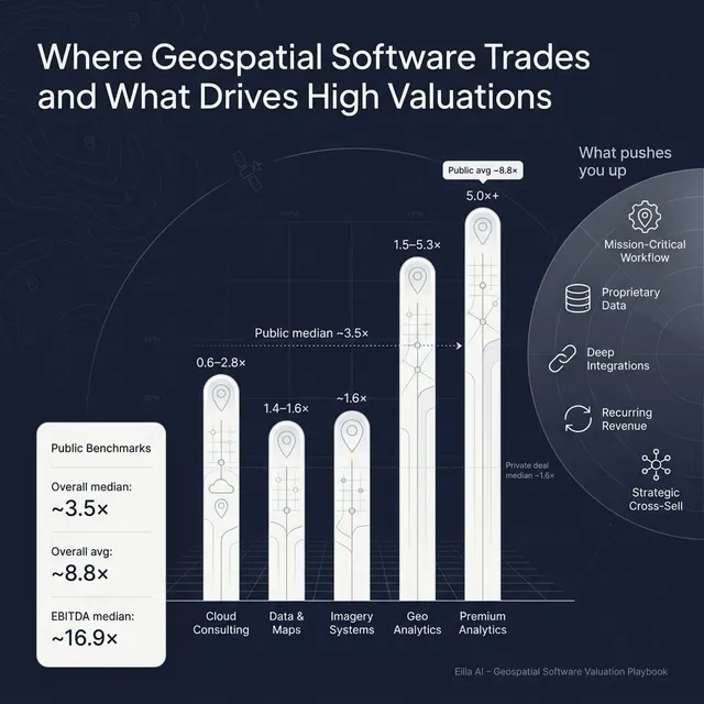
The provided private transaction set shows an overall average EV/Revenue multiple of about 2.9x and a median of about 1.6x. The EV/EBITDA data is thinner, but the average and median in the set are both about 12.7x.
For founder-owned geospatial software businesses, the key message is simple: many real private deals happen below the high public market multiples. Smaller scale, limited growth data, services mix, customer concentration, and lower disclosure tend to pull multiples down.
Still, there is clear variation. Strategic data assets, software-like margins, cross-sell potential, and specialized vertical positioning can support stronger outcomes. More services-heavy, project-based, or generic data businesses tend to sit lower.
These ranges are illustrative, not a formal valuation. A small geospatial SaaS company with recurring revenue and good retention may deserve a higher multiple than a one-off mapping services business. But a founder should not assume that every geospatial software business will receive public SaaS multiples.
4.2 Public Companies
Public markets provide an important reference point, but not a direct price tag for your company. Public companies are usually larger, more liquid, more diversified, and more transparent. Buyers often start with public comps, then adjust down for private company size and risk.
Across the provided public company set, the overall average EV/Revenue multiple is about 8.8x, while the median is about 3.5x. The average is pulled upward by very high-growth or strategically scarce software companies. The median is usually more useful for private company founders because it better reflects the middle of the market.
The overall average EV/EBITDA multiple is about 33.6x, while the median is about 16.9x. Again, the average is influenced by high-multiple public software names, while the median gives a more grounded reference point.
Public company multiples in the data are as of mid to late 2025.
The key lesson is that public geospatial-adjacent software companies with strong growth, large scale, high gross margins, and mission-critical workflows can trade at strong multiples. But public companies with weaker growth, low profitability, services-heavy models, or less differentiated offerings trade much lower.
For founders, public comps should be used as a reference band. They help frame what buyers might pay for scaled, high-quality assets. They do not automatically determine what a smaller private company is worth.
A private business may be valued below public multiples because it is smaller, less liquid, less diversified, or more dependent on a few customers. But it can sometimes attract a strategic premium if a buyer sees something scarce: proprietary data, a hard-to-replace workflow, a highly attractive customer base, or a product that fills a clear gap in the buyer’s platform.
5. What Drives High Valuations - Premium Valuation Drivers
Premium valuations are earned. In geospatial software, buyers pay more when they can clearly see why your business is hard to replace, easy to scale, and valuable to their own strategy.
Mission-critical data and decision workflows
Buyers pay more when your product supports important decisions. That could include infrastructure planning, utility asset management, insurance risk, logistics routing, site selection, defense imagery, environmental reporting, or tourism and destination analytics.
The more your software affects real-world outcomes, the stronger the valuation story. A map that looks good in a presentation is useful. A platform that helps a customer avoid a construction error, reduce fleet cost, improve public safety, or plan infrastructure investment is more valuable.
Practical examples include underground utility mapping, satellite image processing for operational analytics, field operations routing, flood or terrain risk intelligence, and spatial tools tied to compliance reporting.
Large customer base with real expansion potential
A broad customer footprint can help valuation, but only if those customers are active, sticky, and monetizable.
Buyers will not give full credit for thousands of dormant accounts. They want to see renewal rates, usage, upsell history, account expansion, and evidence that customers buy more over time.
For example, a geospatial platform serving many municipal, utility, or field operations customers may have strong expansion potential if it can sell additional modules, more seats, premium data layers, mobile tools, or analytics packages.
Cross-sell value to strategic buyers
Strategic buyers often pay more when your product can be sold into their existing customer base.
This is especially relevant in geospatial software because many large acquirers already own adjacent products: infrastructure design tools, asset management systems, fleet platforms, logistics software, public sector platforms, cloud analytics platforms, or industrial data systems.
If your product can attach naturally to those platforms, the buyer sees more than your current revenue. They see a way to make their own customer base more valuable.
The best version of this story is not "a large buyer could sell us." It is "we have clear proof that their customers need this, and the combined product would solve a bigger problem."
Specialized vertical expertise
Premium value often comes from depth, not breadth.
A generic mapping tool may face many competitors. A geospatial platform built for a specific workflow - such as utilities, defense imagery, logistics, travel intelligence, mining, public safety, or infrastructure lifecycle management - can be much harder to replace.
Specialization matters because it can create product credibility, customer trust, industry-specific data structures, integrations, and regulatory knowledge. Buyers like this because it lowers the risk of commoditization.
Software-like margins and visible profitability
Buyers pay more when a business looks like scalable software, not custom services.
That means high gross margins, repeatable implementation, low support burden, and a clear path from revenue growth to EBITDA. EBITDA is simply operating profit before certain accounting and financing items. It is a common way buyers compare company profitability.
In the provided deal data, the strongest premium signals were tied to companies that combined high gross margins, positive EBITDA, and improving profitability. That tells buyers the business model can scale.
Ecosystem credibility and technical validation
Certifications, partnerships, awards, customer references, and technical credibility can reduce buyer risk.
In geospatial software, credibility matters because many customers are cautious. Government agencies, utilities, infrastructure owners, logistics companies, and defense-related customers do not switch systems casually.
Recognized partnerships with major cloud platforms, proven work in demanding sectors, certifications, or strong customer references can all make demand feel more durable.
Clean financials and a strong management bench
Even if your product is excellent, messy numbers can reduce valuation.
Buyers want clear revenue recognition, clean gross margin reporting, reliable customer metrics, accurate bookings and renewal data, and a management team that can run the business after the deal.
A founder-led business can still command strong value. But if every customer relationship, product decision, and sales process depends on you personally, buyers will apply a risk discount.
6. Discount Drivers - What Lowers Multiples
Discounts usually appear when buyers see risk, uncertainty, or too much work after closing.
The first major discount driver is weak revenue quality. If revenue is mostly project-based, non-recurring, or dependent on a few large one-off contracts, buyers will be cautious. They may still like the business, but they will not value the revenue the same way they value recurring software subscriptions.
The second is low customer stickiness. If customers can leave easily, usage is light, or your product is not embedded in daily workflows, the revenue feels less durable. Buyers will ask: "What stops customers from switching to a cheaper tool or building this internally?"
The third is services-heavy delivery. Many geospatial businesses need implementation, data cleanup, integration, or custom support. That is normal. The problem appears when every new customer requires heavy custom work. That makes growth slower, margins lower, and scaling harder.
The fourth is unclear data defensibility. If your data comes mostly from third parties and competitors can access the same sources, buyers may not view it as a moat. A moat is simply something that protects your business from competition.
The fifth is limited growth proof. A mature business can still sell well, but if there is no evidence of growth, upsell, new product momentum, or market expansion, buyers may cap the multiple.
The sixth is poor profitability or unclear path to profitability. Buyers may accept losses in a high-growth, high-retention SaaS company. But losses without growth are difficult to defend.
Other common discount drivers include customer concentration, weak sales pipeline, messy financial records, founder dependency, outdated technology, unresolved intellectual property issues, data privacy concerns, and unclear ownership of customer data or mapping rights.
Most of these issues can be improved. The key is to address them before a sale process, not after buyers uncover them in diligence.
7. Valuation Example: A Geospatial Software Company
This example is fictional. The company, revenue level, valuation range, and multiples are illustrative only. This is not investment advice, not a fairness opinion, and not a formal valuation.
Imagine a company called NorthGrid Maps.
NorthGrid Maps is a privately held geospatial SaaS business with USD 10m of annual revenue. It sells cloud-based territory mapping, field planning, and location intelligence tools to sales, service, and operations teams. It has a large base of small and mid-sized customers, mostly recurring subscription revenue, and some professional services for onboarding and data configuration.
The right valuation logic starts by selecting the most relevant comps. NorthGrid is not a high-growth fleet telematics platform, not a scaled public infrastructure software company, and not a frontier geospatial data platform with a unique data moat. It is closer to a mature vertical/location-intelligence software business.
The private transaction data suggests that many similar smaller data, mapping, and analytics deals sit around the low-to-mid single-digit revenue multiple range, with the median private transaction revenue multiple around 1.6x and the average around 2.9x. Public location-driven marketing and adjacent SaaS companies provide additional reference points, but they should be adjusted for scale, growth, and quality.
Step 1: Select a core range
For NorthGrid, a reasonable base case might be 1.8x-2.6x revenue.
The low end sits above the pure private mapping-data median because NorthGrid has software characteristics, recurring revenue, and a broad customer base. The high end lines up with stronger location-driven software references, but stays below richer infrastructure, fleet, or premium analytics multiples because there is no evidence of hyper-growth, deep enterprise dominance, or scarce proprietary data.
Step 2: Apply the range to USD 10m of revenue
In the base case, NorthGrid Maps might be worth around USD 18m-26m.
A discounted case could apply if growth is flat, churn is high, revenue is less recurring than expected, customer usage is shallow, or implementation services carry too much of the margin burden.
A premium case could apply if the company has strong growth, high gross margins, very sticky customers, clear expansion revenue, defensible data assets, strong integrations, and a buyer who sees major cross-sell value.
Step 3: What this means for founders
Two geospatial software companies with the same USD 10m of revenue can be worth very different amounts.
One may be a useful but replaceable mapping tool with flat growth and project revenue. Another may be a mission-critical platform with recurring subscriptions, proprietary data, high retention, and clear strategic value to multiple acquirers.
That is why valuation work should start months before a sale. Your goal is not to force a buyer to believe a story. Your goal is to build the evidence that supports the story.
8. Where Your Business Might Fit - Self-Assessment Framework
Use this framework to locate your business roughly within the valuation spectrum. Score each group from 0 to 2.
A score of 0 means the factor is weak or unproven. A score of 1 means it is acceptable but not clearly premium. A score of 2 means it is a real strength and can be backed up with data.
How to interpret your score
If you score 13-16, you are likely closer to the premium end of the market, assuming the numbers are clean and buyers believe the story.
If you score 8-12, you may be in the fair market range. You probably have a sellable business, but there may be clear areas to improve before launching a process.
If you score 0-7, you may still be able to sell, but you should expect buyers to focus on risk. In that case, a 6-12 month preparation plan could make a meaningful difference.
Be honest. The purpose is not to give yourself a flattering score. The purpose is to identify which improvements could have the highest payoff before you go to market.
9. Common Mistakes That Could Reduce Valuation
The first mistake is rushing the sale. If you start talking to buyers before your numbers, story, pipeline, contracts, and data room are ready, you lose control. Buyers see gaps, ask harder questions, and may anchor their offers lower.
The second mistake is hiding problems. If churn is rising, a major customer is at risk, a data license is unresolved, or a product module is underperforming, it will likely surface in diligence. Hiding issues destroys trust. Buyers may reduce price, change terms, demand an earnout, or walk away.
The third mistake is weak financial records. Many founders underestimate how much this matters. Buyers want to see revenue by type, gross margin by product and service line, customer-level retention, recurring versus non-recurring revenue, bookings, backlog, and EBITDA adjustments. If the numbers are messy, buyers assume risk.
The fourth mistake is not improving easy issues before going to market. In 6-12 months, you may be able to improve margin reporting, clean up revenue recognition, document customer retention, reduce unnecessary costs, increase pricing discipline, and organize key metrics. These are not massive strategic pivots, but they can improve buyer confidence.
The fifth mistake is running an unstructured sale process. Research and market experience show that a structured competitive process with an advisor typically leads to meaningfully higher purchase prices, often around 25%, because more qualified buyers are engaged and forced to compete. One buyer alone rarely gives you full price discovery.
The sixth mistake is revealing your target price too early. If you say you want USD 10m of enterprise value, buyers will often come back at USD 10.1m or USD 10.2m, even if they might have paid more. Let the market tell you what the business is worth.
The seventh mistake is industry-specific: failing to explain your data rights and dependencies. In geospatial software, buyers will care about who owns the data, what comes from third parties, what is licensed, what is proprietary, and what happens if a data provider changes terms.
The eighth mistake is positioning the company too generically. "We provide mapping software" is not enough. A stronger story is: "We help utilities reduce asset risk," "We help logistics teams cut route cost," or "We help infrastructure owners manage critical location data."
10. What Geospatial Software Founders Can Do in 6-12 Months to Increase Valuation
Improve the numbers buyers will underwrite
Start by cleaning up revenue reporting. Separate recurring subscription revenue, usage-based revenue, services revenue, data revenue, and one-off project revenue. Buyers need to understand what repeats and what does not.
Track gross margin by revenue type. A blended gross margin can hide the real story. If software gross margin is strong but services margin is weaker, show that clearly.
Build a simple retention analysis. Show how much revenue renews, how much expands, and how much is lost. Buyers care deeply about whether customers stick around and pay more over time.
Strengthen the mission-critical story
Document the workflows where your software is essential. Do customers use you for asset management, planning, routing, compliance, infrastructure records, field operations, risk analysis, or customer engagement?
Collect customer proof. Case studies, usage data, renewal history, and reference calls can all help buyers believe the story.
Map your integrations. If you connect to CRM, ERP, field service, fleet systems, cloud data platforms, sensor data, or infrastructure systems, show how those integrations increase switching costs.
Reduce obvious risk
Review customer concentration. If one or two customers represent too much revenue, show a plan to reduce dependence or prove those relationships are secure.
Check data rights. Make sure contracts, licenses, and customer data permissions are organized and buyer-ready.
Reduce founder dependency. Move key customer relationships, product knowledge, and sales processes into the team. Buyers pay more when the business can operate without the founder being involved in every decision.
Improve the growth story
Identify expansion opportunities inside the existing customer base. Can you sell more users, more data layers, more regions, more modules, or higher-tier plans?
Improve pricing. Many founder-led software businesses are underpriced relative to the value they create. Even modest price increases, if supported by retention, can help valuation.
Build a credible pipeline. Buyers do not need fantasy forecasts. They need a believable view of signed contracts, late-stage opportunities, renewal timing, and expansion potential.
Prepare the sale process properly
Build a data room before buyer outreach. Include financials, customer metrics, product materials, contracts, employee information, data rights, intellectual property records, and key performance indicators.
Prepare the valuation story. Know whether you are best positioned as geospatial SaaS, infrastructure software, fleet and operations software, data intelligence, or location-based marketing technology.
Most importantly, create buyer competition. In this sector, the right buyer may not be obvious. It could be a geospatial software company, a data platform, a fleet software provider, a public sector technology buyer, an infrastructure software company, or a private equity-backed platform.
11. How an AI-Native M&A Advisor Helps
An AI-native M&A advisor can help you reach a broader and more relevant buyer universe. AI can screen hundreds of potential acquirers based on deal history, strategic fit, product synergies, financial capacity, sector focus, and acquisition behavior. More relevant buyers usually means more competition, stronger offers, and a higher chance the deal closes if one buyer drops out.
AI can also speed up the early part of the process. Buyer matching, buyer outreach support, marketing material creation, and due diligence preparation can move faster than in a manual-only process. That can help founders reach initial conversations and offers in under 6 weeks, depending on readiness and buyer response.
The best model is not AI replacing expert advisors. It is expert human M&A advisors using AI to work faster, cover more ground, and frame the business more effectively. You still need experienced advisors who understand buyer psychology, negotiation, valuation, process tension, and how to present your company credibly.
For geospatial software founders, the goal is simple: broader buyer reach, better-prepared materials, stronger positioning, and a more competitive process - without traditional bulge bracket costs. If you would like to understand how our AI-native process can support your exit, book a demo with one of our expert M&A advisors.
Are you considering an exit?
Meet one of our M&A advisors and find out how our AI-native process can work for you.


